Showing posts with label severe. Show all posts
Wednesday, June 1, 2011
Severe weather potential for N-Italy, June 6th/7th
Weak trough passes through central Europe, showing some signs of storm potential. As I look at it now, the limiting factor will be the upper level flow, only at 30kts @ 500mb which is seriously borderline. Low level winds on the other hands are quite good, with good speeds and direction make up for a nice veering profile. Higher CAPE is forecast on June 7th with more marginal conditions on June 6th. The cap will be somewhat moderate, but with lack of surface convergence, initiation is questionable. WRF is even drawing a 10m wind divergence in FVG region. Stay tuned for updates and detailed analysis in the next few days.
Thursday, May 26, 2011
Severe storms potential on Friday in FVG, Italy
Severe weather is expected on Friday afternoon in Italy, Austria, Slovenia and Hungary as the trough advances eastward. The trough will provide a 15-20 m/s 500mb jet and adequate lift on the front which comes in the late afternoon in N-Italy, N-Slovenia and W-Hungary. Models still do not agree with each other on how much CAPE will be available although they are starting to converge. GFS forecasts >1000 J/kg in NE-Slovenia, >1500 J/kg in N-Croatia and only a couple of hundred in central Italy with marginal CAPE in Friuli-Venezia region. ECMWF and GFS are drawing more CAPE in FVG region and less in NE-Slovenia.
The wind profile is great in the FVG region and a lot worse elsewhere. Medium SRH3 and nice veering suggest for potentially tornadic supercells. That will be basically the only interesting region. Other locations have more or less uni-directional shear so linear storms will probably be the primary mode. Still, large hail is definitely a danger, including severe wind gusts, but to a lesser extent, given the high moisture and PWAT values. High PWAT values also suggest HP supercells in the FVG region. With some low-level shear, tornado is not ruled out.
My biggest concern is the capped atmosphere in the FVG region. Elsewhere the cap will be broken rather easily. I remain somewhat sceptical for Italy. There is a strong convergence west of Venezia and Bologna, but the lack of serious lift in FVG region, the initiation prior to the front is questionable. Once the front comes, there will be no problem with initiation, but this will probably be rather late. I think the CIN will be in the 30-60J range and with the lack of serious convergence zones the initiation can be late.
The severe weather potential in NE-Slovenia and elsewhere along the front will be limited due to lack of low-level shear and these locations are probably not the best chasing targets.
Monday, April 25, 2011
Severe weather weekly forecast for central Europe 25.4. - 1.5. 2011
Week 5 : April 25th - May 1st
High pressure system still mostly dominates Europe. Scattered thunderstorms are forecast across most of central and eastern Europe for Monday. Marginal cape is available in those areas with the largest CAPE (around 500-600 J/kg) in N-Italy, Slovenia and Hungary. Weak DLS will prevent severe weather with the exception of a small jet-stream above Slovakia, Austria and Poland where 20 m/s is present and could produce some large hail and/or strong wind. Strong convergence is present along the Dinaric mountains in Slovenia and eastern Alps region in Austria towards Hungary. This is where the convection will likely fire first.
With the maximum temperatures around 20°C later this week, severe weather will be diminished, but the potential returns in the beginning of May, when GFS is drawing some interesting setups.
Monday, April 18, 2011
Severe weather weekly forecast for CTRL-Europe 18.4. - 24.4. 2011
Week 4 : April 18th - April 24th
Huge anticyclonic system is currently in place and will dominate the weather in central Europe in the next 1-2 weeks. There will some scattered instability (not larger than 500-600 J/kg) but due to non-existent wind shear no severe weather will happen. Very stable weather is expected, in fact, looking at the picture lower, I have not yet seen this kind of agreeing between different GFS ensemble runs. Usually, they are all over the place. This time, even 14 days ahead, all ensembles are relatively closely together. Plan a picnic because no storm chasing is going to happen this week (and probably the next one). Well, it's April, what do you expect?
Sea temperature in the Mediterranean sea are still rather low and haven't warmed up significantly in the last weeks, still in the 15°C range.
Monday, April 11, 2011
Severe weather weekly forecast for CTRL-Europe 11.4. - 17.4. 2011
Week 3 : April 11th - April 18th
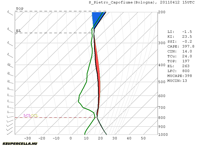
Another front will pass central Europe on Tuesday afternoon/evening. The bad news is the front will come rather late in the evening across the Alps. There should be enough CAPE for moderate convection. Best CAPE is forecast around Bologna-Venice region where GFS is drawing around 600 J/kg, but marginal CAPE will be present all the way from W-Italy to E-Hungary. Decent deep-layer shear will be present (>15 m/s), but with the lack of any low-level jet, storms will tend to merge into lines on the front. The best conditions for rotating storms are south of Venice where some veering winds and consequently moderate SREH3 are present. With some organization, large hail is possible. Pre-frontal afternoon initiation is questionable given the lack of serious convergence, but there will be only little CIN (up to 50 J/kg) so diurnal heating could speed things up.
Another interesting area will be in NE-Slovenia and W-Hungary. Strong backing winds will be present but with little CAPE. Storms on the front will quickly get elevated and any severe threat will be diminished rather soon.
After the front will pass, the air will stabilize and we do not expect any severe weather threats soon.
Sunday, April 3, 2011
Severe weather weekly forecast for CTRL-Europe 4.4. - 10.4. 2011
Week 2: April 4th - April 10th
A cold front from the N-NW will affect the weather in the beginning of the week passing through N-Italy, Slovenia and Hungary on Monday afternoon, from 15Z onward. There will be a small CAPE buildup meaning only marginal instability. Only moderate shear is forecast so little organization will be possible. Widespread weak convection with some lightning should be observed on the front with rain.
We should experience another weak front on Friday. Max temperatures will be around 25°C with limited convective potential. Air will be mostly stable over the course of the week. Higher convective potential is possible next weekend, GFS is currently forecasting 600 J/kg CAPE but it is still too far away to make and conclusions. This instability is non-frontal based just on higher moisture content so GFS is likely to change his mind in the next run.
Saturday, March 26, 2011
Severe weather weekly forecast for central Europe - 28.3. to 4.4. 2011
From April on I'll be doing weekly forecasts for convective weather for central Europe. I will be analysing synoptic scale weather, severe convective situations and storm chasing opportunities for the upcoming week. Detailed analysis for especially interesting situations will be written in separate blog posts. Let's start.
Week 1: March 28th - April 3rd
Nothing particularly interesting in terms of severe weather is going to happen in the following week. Weak cold front will affect the weather in the beginning of the week but it is quickly going to bounce off with Tmax ranging from 15 to 20 °C in the next days all the way to the end of the week, when they will be topping 20°C. Dewpoints will remain low due to low moisture (around 7g/kg) barely topping 12°C. CAPE buildup will therefore be limited to a couple of hundred J/kg in higher moisture areas.
Sea temperatures are still low, but with warmer weather that will change soon. Northern Adriatic sea has about 10-11°C while Mediteranian sea has about 14°C.
Thursday, March 11, 2010
European Storm Season Duration: When to chase?
We all know the real storm season in the USA starts in April, peaks in May, remains very active in June and then declines fast in July, with less activity in August.
What about Europe?
I have made a quick research using ESSLs (European Severe Storm Laboratories) severe weather database (ESWD). I divided the months in half for a better sample recognition and searched the number of reports for each period for years 2002 until 2011. I searched reports for tornadoes, large hail, heavy rainfall, funnel clouds and severe wind gusts. The number of reports for the first years are very scarce. I got the next graph :
It is evident that the storm season does not start before late April/early May. In the summer the activity is evenly distributed until August when the activity drops. Convective weather gets very rare in late September. Coastal cities around the Mediterranean profit from the warm sea feeding the energy in those months. Of course you can find reports of severe weather in non-storm season months too. Very large hail reports in March and tornado outbreaks in April are not that uncommon! The pattern in the graph above represents the whole Europe, with northern countries having shorter and southern countries longer storm seasons.
Reports in the winter months are mostly from severe wind gusts and heavy rainfall (non convective weather), but I did not filter out every such event for obvious reasons.
Subscribe to:
Posts (Atom)