Anyone that has chased at least a couple of times knows that even when the forecast is great, you can find yourself sitting hundreds of kilometers away from home, under blue skies, without a single cloud. There is a lot of energy in the air (high CAPE values), good low level and deep layer shear but no storms 500 km from you. Where is the problem?
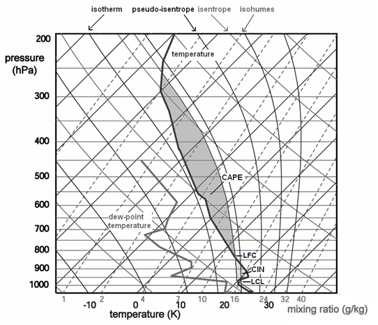
The problem is in the "cap". Cap, also called the convective inhibition (CIN or CINH) is a thermal inversion above the warm, moist air. CINH is the area of the sounding between the surface and the level at which CAPE begins. The CINH is the air that is not buoyant and must be "broken" for the development of deep convection. The upper border, where CINH ends, is called the Level of Free Convection (LFC).
 |
| Estofex.org |
Convective inhibition is most commonly caused by night-time cooling (this is why storms are more common in the afternoon than in the morning). Other causes for the cap formation are: sinking air aloft, horizontal advection of hot air and a shallow cold front.
How can the cap be broken? There are number of ways that can work alone or in combination:
1) Daytime heating
2) Moistening (low level warm/moist air advection)
3) Synoptic scale lifting
Daytime heating and moistening brings the moist adiabatic line on the Skew-T diagram to the right, minimizing the cap. Early in the morning we should be looking at cloud coverage in the area of forecast thunderstorms. If there is strong cap and a thick cloud layer there is very little chance for the sun to break it.
Synoptic scale ascent lifts and weakens the inversion layer or brings it completely to the right side of the moist adiabatic line, thus making it buoyant.
Assessing synoptic scale lift
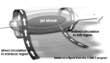
Synoptic scale ascent is caused either by a low-level convergence or jet streak divergence. Low level convergence happens when two air masses, that are traveling at different speeds or directions, bump into each other, causing the air to lift (it can only go up). Local areas of strong upper level flow, or jet streaks, have an associated pattern of upward and downward motion. If we are dealing with an ideal jet streak, the left exit quadrant of the jet and the right entrance quadrant of its entrance region are associated with divergence.
 |
| Estofex.org |
 |
| Estofex.org |
How much CINH is too much? Or too little?
Experiences show us that more than 200 J/kg of CINH is too much and such cap can't be broken only by the daytime heating. Anywhere from 50-150 J/kg is moderate CINH and a cap below 50J/kg is too weak and is broken much too early. If the CINH is too large we could be looking at blue skies all day long, even if the CAPE values are large. The cap will not be broken. Moderate CINH is the most favorable for severe weather development, because it can hold the convection until late afternoon, after a lot of daytime heating when the convective energy is maximized. The storms can fire up being isolated without having to compete with surrounding cells. Low CINH values suggest easy and early convection meaning the atmosphere will already be mixed by mid-day and the potential will never be reached. We would be looking at clouds and numerous cells firing up without any serious organization.
Knowing and understanding the convective inhibition is critical in forecasting severe weather. Any storm chaser should have a detailed knowledge of it in order to storm chase successfully.
Pieter Groenemeijer, Ari-Juhani Punkka, Jenni Teittinen. Forecasting Severe Convective Storms. Retrieved February 15th, 2011 from http://www.estofex.org/guide/
Tim Marshall. The Cap: It's Boom or Bust! Storm Track, May 31, 1988 Retrieved February 15th, 2011 from http://www.stormtrack.org/library/forecast/cap.htm