Showing posts with label CAPE. Show all posts

Saturday, June 18, 2011

Serious potential for strong (tornadic) supercells on June 18th in FVG, Italy

Estofex gave LVL2 for today in N-Italy and the setup really is very good. I won't really into details because time is not on my side. Just a quick writeup. 50 kt 0-6 km shear combined with good SFC winds with nice veering and moderate CAPE values suggests serious potential. The best potential is again in the FVG region where winds are the best. The cap is not small and there is no serious 10m convergence until 18Z so we will see if it can break it anyway. PWAT values are ridiculousy high, in the 42mm range, so everything points to (potentially tornadic) HP supercells. Good luck to everyone who will chase today. I won't be chasing because of college work. :(


Friday, June 3, 2011

Follow up on the June 6th setup

For initial analysis view the previous post. Potential for the June 7th has vanished due to weak 0-6km shear. June 6th looks solid, the 500mb jet is going to be stronger than expected at first.

We are dealing with 35-45 kt 500mb jet through northern Croatia, Slovenia and NE-Italy, around 30kt @ 700mb, 20kt @ 850mb and around 10kt @ 925mb and 10m. Limiting factor is the unidirectional shear, which limits helicity, so supercells are possible, but not very likely. Storms will tend to get linear. Focus will be on the southern flanks of the lines for possible tail-end charlies. CAPE will range from 500 to 2000 J/kg according to WRF and GFS, locally maybe even more. Areas with high CAPE are forecast in CNTR-Italy, E-Slovenia and N-Croatia. No significant convergence lines other than above the Dinaric mountain range and the Alps are forecast, but the CINH will be rather small and with some daytime heating we should have no problem seeing breaking the cap. Similar conditions exist for E-Austria and W-Hungary.


Thursday, May 26, 2011

Severe storms potential on Friday in FVG, Italy

Severe weather is expected on Friday afternoon in Italy, Austria, Slovenia and Hungary as the trough advances eastward. The trough will provide a 15-20 m/s 500mb jet and adequate lift on the front which comes in the late afternoon in N-Italy, N-Slovenia and W-Hungary. Models still do not agree with each other on how much CAPE will be available although they are starting to converge. GFS forecasts >1000 J/kg in NE-Slovenia, >1500 J/kg in N-Croatia and only a couple of hundred in central Italy with marginal CAPE in Friuli-Venezia region. ECMWF and GFS are drawing more CAPE in FVG region and less in NE-Slovenia.
The wind profile is great in the FVG region and a lot worse elsewhere. Medium SRH3 and nice veering suggest for potentially tornadic supercells. That will be basically the only interesting region. Other locations have more or less uni-directional shear so linear storms will probably be the primary mode. Still, large hail is definitely a danger, including severe wind gusts, but to a lesser extent, given the high moisture and PWAT values. High PWAT values also suggest HP supercells in the FVG region. With some low-level shear, tornado is not ruled out.


My biggest concern is the capped atmosphere in the FVG region. Elsewhere the cap will be broken rather easily. I remain somewhat sceptical for Italy. There is a strong convergence west of Venezia and Bologna, but the lack of serious lift in FVG region, the initiation prior to the front is questionable. Once the front comes, there will be no problem with initiation, but this will probably be rather late. I think the CIN will be in the 30-60J range and with the lack of serious convergence zones the initiation can be late.

The severe weather potential in NE-Slovenia and elsewhere along the front will be limited due to lack of low-level shear and these locations are probably not the best chasing targets.

Friday, May 20, 2011

Azor anticyclone dominating weather in Europe

Most of Europe is currently under the influence of a major Azor anticyclone which does not allow any trough to pass through central and southern Europe. It does not look like the pattern will change in the next 7-10 days, but GFS was offering some hope yesterday when it forecast a nice trough with serious setup potential. We will see how that develops. Meanwhile the SSTs in the Mediterranean sea are currently somewhat stagnant but will rise during this pattern of warm weather.

A lot of CAPE will be available for the storms is next days across most of Europe but given the basically non-existent shear there is no severe weather threat at least 7-10 days ahead. Azor anticyclone is just too strong currently. There could be some nice lightning displays though.


Saturday, April 30, 2011

April 25–28 Epic tornado outbreak in the USA

A violent tornado outbreak from April 25 – 28, 2011, affected the Southern Midwestern, and Eastern United States, leaving catastrophic destruction behind. At this time there are more than 350 casualties confirmed but the number is still rising.

It was really an amazing setup, just by looking at the numbers. These were the conditions in Alabama:
CAPE : 1000-2000 J/kg
0-6km shear: 70 kts
SREH3: 1100 m2/s2 (!!!)
Significant tornado parameter : 13.0
Supercell composite parameter : >40

These numbers are mind-blowing and we probably won't see this kind of setup for quite some time.

Some interesting images from the supercell that dropped the tornado that hit Tuscaloosa and Birmingham:

Tornado track in Tuscaloosa.

Tornado tracks clearly visible from space. Look how huge the track is! Credit: NASA


Most violent supercell of this tornado outbreak in Alabama.


Crazy hook echo with debris ball.


Monday, April 11, 2011

Severe weather weekly forecast for CTRL-Europe 11.4. - 17.4. 2011

Week 3 : April 11th - April 18th

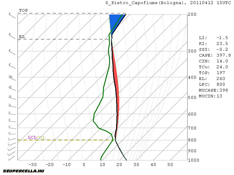
Another front will pass central Europe on Tuesday afternoon/evening. The bad news is the front will come rather late in the evening across the Alps. There should be enough CAPE for moderate convection. Best CAPE is forecast around Bologna-Venice region where GFS is drawing around 600 J/kg, but marginal CAPE will be present all the way from W-Italy to E-Hungary. Decent deep-layer shear will be present (>15 m/s), but with the lack of any low-level jet, storms will tend to merge into lines on the front. The best conditions for rotating storms are south of Venice where some veering winds and consequently moderate SREH3 are present. With some organization, large hail is possible. Pre-frontal afternoon initiation is questionable given the lack of serious convergence, but there will be only little CIN (up to 50 J/kg) so diurnal heating could speed things up.

Another interesting area will be in NE-Slovenia and W-Hungary. Strong backing winds will be present but with little CAPE. Storms on the front will quickly get elevated and any severe threat will be diminished rather soon.

After the front will pass, the air will stabilize and we do not expect any severe weather threats soon.


Thursday, April 7, 2011

Small CAPE/large shear setups

In the spring we are dealing with a lot of situations where there is weak or marginal cape and large deep layer and low level shear. These situations can sometimes produce strong tornadic supercells providing large storm relative helicity values. I've stumbled across this interesting point made by Jon Davies on his blog. You can read it HERE.

Similar conditions are currently in southern Poland, Slovakia and further to the south-east. No reports yet. Strong SREH3 is forecast tommorow in the same area with marginal CAPE. Tornadoes are possible.

Sunday, April 3, 2011

Severe weather weekly forecast for CTRL-Europe 4.4. - 10.4. 2011

Week 2: April 4th - April 10th

A cold front from the N-NW will affect the weather in the beginning of the week passing through N-Italy, Slovenia and Hungary on Monday afternoon, from 15Z onward. There will be a small CAPE buildup meaning only marginal instability. Only moderate shear is forecast so little organization will be possible. Widespread weak convection with some lightning should be observed on the front with rain.


We should experience another weak front on Friday. Max temperatures will be around 25°C with limited convective potential. Air will be mostly stable over the course of the week. Higher convective potential is possible next weekend, GFS is currently forecasting 600 J/kg CAPE but it is still too far away to make and conclusions. This instability is non-frontal based just on higher moisture content so GFS is likely to change his mind in the next run.

Saturday, March 26, 2011

Severe weather weekly forecast for central Europe - 28.3. to 4.4. 2011

From April on I'll be doing weekly forecasts for convective weather for central Europe. I will be analysing synoptic scale weather, severe convective situations and storm chasing opportunities for the upcoming week. Detailed analysis for especially interesting situations will be written in separate blog posts. Let's start.

Week 1: March 28th - April 3rd

Nothing particularly interesting in terms of severe weather is going to happen in the following week. Weak cold front will affect the weather in the beginning of the week but it is quickly going to bounce off with Tmax ranging from 15 to 20 °C in the next days all the way to the end of the week, when they will be topping 20°C. Dewpoints will remain low due to low moisture (around 7g/kg) barely topping 12°C. CAPE buildup will therefore be limited to a couple of hundred J/kg in higher moisture areas.
Sea temperatures are still low, but with warmer weather that will change soon. Northern Adriatic sea has about 10-11°C while Mediteranian sea has about 14°C.

Sunday, February 21, 2010

The Cap: Storms vs. Blue Skies

Anyone that has chased at least a couple of times knows that even when the forecast is great, you can find yourself sitting hundreds of kilometers away from home, under blue skies, without a single cloud. There is a lot of energy in the air (high CAPE values), good low level and deep layer shear but no storms 500 km from you. Where is the problem?

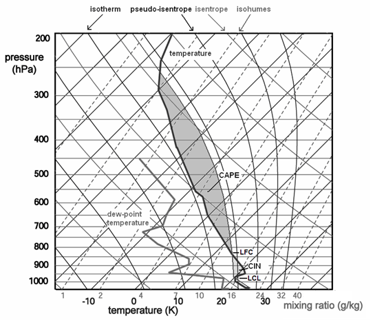
The problem is in the "cap". Cap, also called the convective inhibition (CIN or CINH) is a thermal inversion above the warm, moist air. CINH is the area of the sounding between the surface and the level at which CAPE begins. The CINH is the air that is not buoyant and must be "broken" for the development of deep convection. The upper border, where CINH ends, is called the Level of Free Convection (LFC).

Estofex.org

Convective inhibition is most commonly caused by night-time cooling (this is why storms are more common in the afternoon than in the morning). Other causes for the cap formation are: sinking air aloft, horizontal advection of hot air and a shallow cold front.

How can the cap be broken? There are number of ways that can work alone or in combination:

1) Daytime heating
2) Moistening (low level warm/moist air advection)
3) Synoptic scale lifting

Daytime heating and moistening brings the moist adiabatic line on the Skew-T diagram to the right, minimizing the cap. Early in the morning we should be looking at cloud coverage in the area of forecast thunderstorms. If there is strong cap and a thick cloud layer there is very little chance for the sun to break it.

Synoptic scale ascent lifts and weakens the inversion layer or brings it completely to the right side of the moist adiabatic line, thus making it buoyant.

Assessing synoptic scale lift

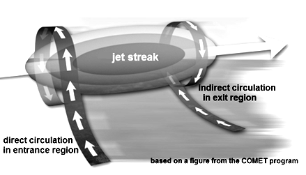
Synoptic scale ascent is caused either by a low-level convergence or jet streak divergence. Low level convergence happens when two air masses, that are traveling at different speeds or directions, bump into each other, causing the air to lift (it can only go up). Local areas of strong upper level flow, or jet streaks, have an associated pattern of upward and downward motion. If we are dealing with an ideal jet streak, the left exit quadrant of the jet and the right entrance quadrant of its entrance region are associated with divergence.

Estofex.org
Estofex.org

How much CINH is too much? Or too little?

Experiences show us that more than 200 J/kg of CINH is too much and such cap can't be broken only by the daytime heating. Anywhere from 50-150 J/kg is moderate CINH and a cap below 50J/kg is too weak and is broken much too early. If the CINH is too large we could be looking at blue skies all day long, even if the CAPE values are large. The cap will not be broken. Moderate CINH is the most favorable for severe weather development, because it can hold the convection until late afternoon, after a lot of daytime heating when the convective energy is maximized. The storms can fire up being isolated without having to compete with surrounding cells. Low CINH values suggest easy and early convection meaning the atmosphere will already be mixed by mid-day and the potential will never be reached. We would be looking at clouds and numerous cells firing up without any serious organization.

Knowing and understanding the convective inhibition is critical in forecasting severe weather. Any storm chaser should have a detailed knowledge of it in order to storm chase successfully.

Pieter Groenemeijer, Ari-Juhani Punkka, Jenni Teittinen. Forecasting Severe Convective Storms. Retrieved February 15th, 2011 from http://www.estofex.org/guide/

Tim Marshall. The Cap: It's Boom or Bust! Storm Track, May 31, 1988 Retrieved February 15th, 2011 from http://www.stormtrack.org/library/forecast/cap.htm