Most of Europe is currently under the influence of a major Azor anticyclone which does not allow any trough to pass through central and southern Europe. It does not look like the pattern will change in the next 7-10 days, but GFS was offering some hope yesterday when it forecast a nice trough with serious setup potential. We will see how that develops. Meanwhile the SSTs in the Mediterranean sea are currently somewhat stagnant but will rise during this pattern of warm weather.
A lot of CAPE will be available for the storms is next days across most of Europe but given the basically non-existent shear there is no severe weather threat at least 7-10 days ahead. Azor anticyclone is just too strong currently. There could be some nice lightning displays though.
Showing posts with label central. Show all posts
Friday, May 20, 2011
Monday, April 11, 2011
Severe weather weekly forecast for CTRL-Europe 11.4. - 17.4. 2011
Week 3 : April 11th - April 18th
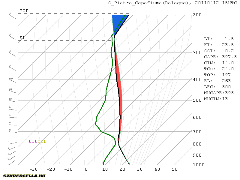
Another front will pass central Europe on Tuesday afternoon/evening. The bad news is the front will come rather late in the evening across the Alps. There should be enough CAPE for moderate convection. Best CAPE is forecast around Bologna-Venice region where GFS is drawing around 600 J/kg, but marginal CAPE will be present all the way from W-Italy to E-Hungary. Decent deep-layer shear will be present (>15 m/s), but with the lack of any low-level jet, storms will tend to merge into lines on the front. The best conditions for rotating storms are south of Venice where some veering winds and consequently moderate SREH3 are present. With some organization, large hail is possible. Pre-frontal afternoon initiation is questionable given the lack of serious convergence, but there will be only little CIN (up to 50 J/kg) so diurnal heating could speed things up.
Another interesting area will be in NE-Slovenia and W-Hungary. Strong backing winds will be present but with little CAPE. Storms on the front will quickly get elevated and any severe threat will be diminished rather soon.
After the front will pass, the air will stabilize and we do not expect any severe weather threats soon.
Another front will pass central Europe on Tuesday afternoon/evening. The bad news is the front will come rather late in the evening across the Alps. There should be enough CAPE for moderate convection. Best CAPE is forecast around Bologna-Venice region where GFS is drawing around 600 J/kg, but marginal CAPE will be present all the way from W-Italy to E-Hungary. Decent deep-layer shear will be present (>15 m/s), but with the lack of any low-level jet, storms will tend to merge into lines on the front. The best conditions for rotating storms are south of Venice where some veering winds and consequently moderate SREH3 are present. With some organization, large hail is possible. Pre-frontal afternoon initiation is questionable given the lack of serious convergence, but there will be only little CIN (up to 50 J/kg) so diurnal heating could speed things up.
Another interesting area will be in NE-Slovenia and W-Hungary. Strong backing winds will be present but with little CAPE. Storms on the front will quickly get elevated and any severe threat will be diminished rather soon.
After the front will pass, the air will stabilize and we do not expect any severe weather threats soon.
Sunday, April 3, 2011
Severe weather weekly forecast for CTRL-Europe 4.4. - 10.4. 2011
Week 2: April 4th - April 10th
A cold front from the N-NW will affect the weather in the beginning of the week passing through N-Italy, Slovenia and Hungary on Monday afternoon, from 15Z onward. There will be a small CAPE buildup meaning only marginal instability. Only moderate shear is forecast so little organization will be possible. Widespread weak convection with some lightning should be observed on the front with rain.
We should experience another weak front on Friday. Max temperatures will be around 25°C with limited convective potential. Air will be mostly stable over the course of the week. Higher convective potential is possible next weekend, GFS is currently forecasting 600 J/kg CAPE but it is still too far away to make and conclusions. This instability is non-frontal based just on higher moisture content so GFS is likely to change his mind in the next run.
A cold front from the N-NW will affect the weather in the beginning of the week passing through N-Italy, Slovenia and Hungary on Monday afternoon, from 15Z onward. There will be a small CAPE buildup meaning only marginal instability. Only moderate shear is forecast so little organization will be possible. Widespread weak convection with some lightning should be observed on the front with rain.
We should experience another weak front on Friday. Max temperatures will be around 25°C with limited convective potential. Air will be mostly stable over the course of the week. Higher convective potential is possible next weekend, GFS is currently forecasting 600 J/kg CAPE but it is still too far away to make and conclusions. This instability is non-frontal based just on higher moisture content so GFS is likely to change his mind in the next run.
Saturday, March 26, 2011
Severe weather weekly forecast for central Europe - 28.3. to 4.4. 2011
From April on I'll be doing weekly forecasts for convective weather for central Europe. I will be analysing synoptic scale weather, severe convective situations and storm chasing opportunities for the upcoming week. Detailed analysis for especially interesting situations will be written in separate blog posts. Let's start.
Week 1: March 28th - April 3rd
Nothing particularly interesting in terms of severe weather is going to happen in the following week. Weak cold front will affect the weather in the beginning of the week but it is quickly going to bounce off with Tmax ranging from 15 to 20 °C in the next days all the way to the end of the week, when they will be topping 20°C. Dewpoints will remain low due to low moisture (around 7g/kg) barely topping 12°C. CAPE buildup will therefore be limited to a couple of hundred J/kg in higher moisture areas.
Sea temperatures are still low, but with warmer weather that will change soon. Northern Adriatic sea has about 10-11°C while Mediteranian sea has about 14°C.
Week 1: March 28th - April 3rd
Nothing particularly interesting in terms of severe weather is going to happen in the following week. Weak cold front will affect the weather in the beginning of the week but it is quickly going to bounce off with Tmax ranging from 15 to 20 °C in the next days all the way to the end of the week, when they will be topping 20°C. Dewpoints will remain low due to low moisture (around 7g/kg) barely topping 12°C. CAPE buildup will therefore be limited to a couple of hundred J/kg in higher moisture areas.
Sea temperatures are still low, but with warmer weather that will change soon. Northern Adriatic sea has about 10-11°C while Mediteranian sea has about 14°C.
Subscribe to:
Posts (Atom)